
We started here, with the shaded rectangle being the 1882 Powell-Harrison proposal:

We then went down to here, with the congressionally approved Park of 1919:

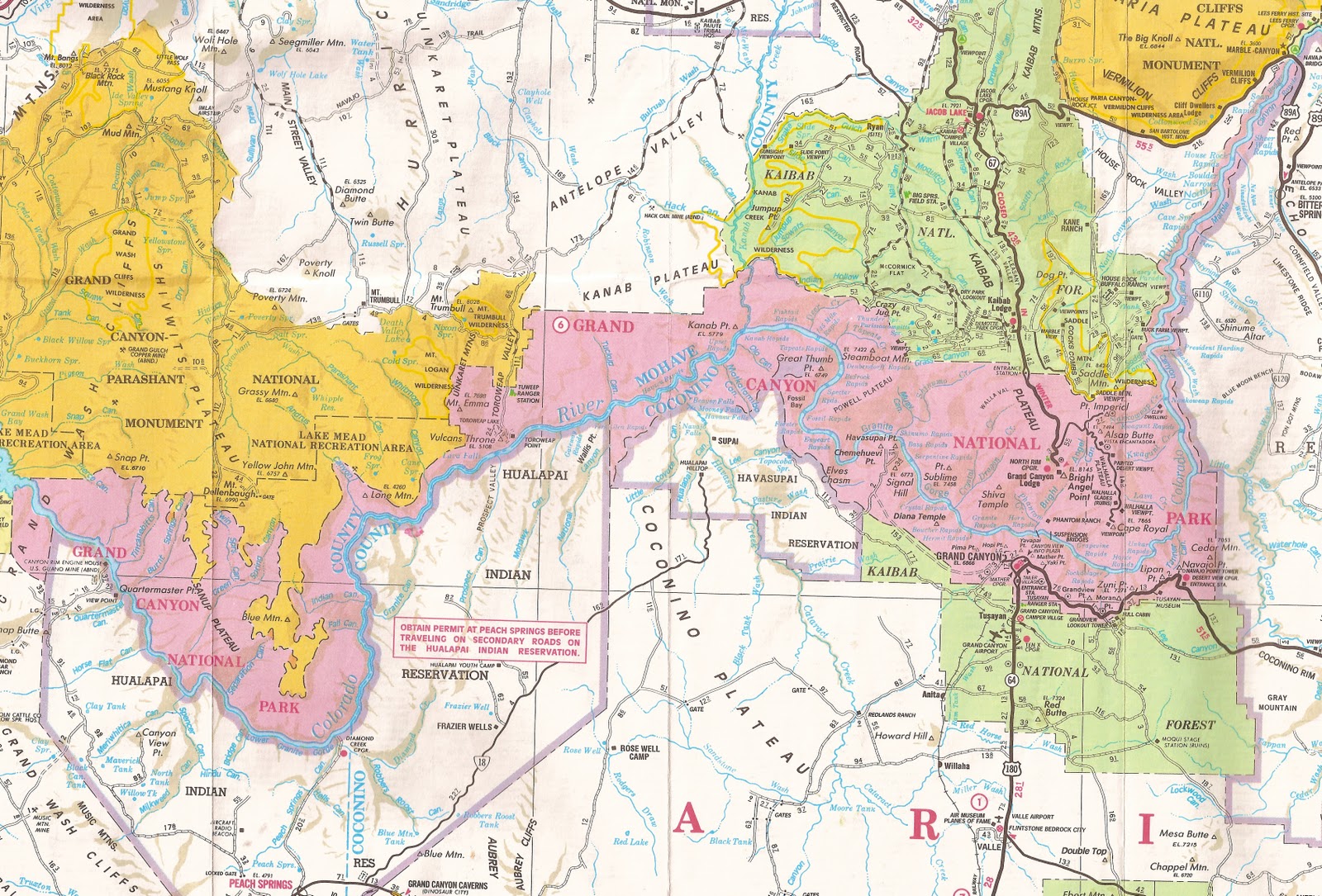
Today, after various moves, we are here, as shown on the ever-useful and inspiring 2002 "Indian Country" map of the Automobile Club of Southern California:
So how did we do it?
How did we get from that pretty big, if somewhat misoriented, rectangle of 1882--
to that cramped 1919 Big Hole bedeviled by claims of a dozen special interests --
to something that is now approaching -- not yet there, for sure, but approaching -- a GCNP that can shake hands with the two wild and not always politically correct schemes I have mentioned.
First, from 1910, the American Scenic and Historic Preservation Society offering (updated courtesy of a Google terrain map):

And then, from 1968, the Sierra Club's strange bird:

How did this all come about? Ah, the mystery of political affairs: The result of a collection of myriad personalities and role-playing, people with their dreams and schemes, plans, actions, brilliances and stupidities, successes and errors, all adding or subtracting their bits and pieces over 130 years in a variety of venues, using all their tools of persuasion, demands, arguments, obstructions, vetos, and approvals. But thats just rhetoric, trying to sound good. What it really is, this incalculable story, is a mystery.
Somehow, in spite of the impossibility of prediction, and in spite of the multitude of differing paths that others wanted to take the Canyon down, we have moved in our erratic political way closer and closer to the realization of this idea:
The Grand Canyon -- that premier global icon of the importance of the natural world to human existence, continuance, sanity -- must be conceived of, presented as, protected from pettiness within, the highest imaginable celebratory designation. Where the Canyon is federal land, the property of all the American people, that designation is as a National Park. Where there are other owners, they will express their own appropriate recognition, something I have only explored a little in this blog, but to which I will return.
Clearly though, my responsibility is first to finish laying out the loopy path our American political system has taken to institute, and then strengthen, our commitment to embed the icon, to celebrate the Canyon, as an entity identifiable to the public, unified in presentation as a National Park.
How did we get this far? There is no fore-ordained flow of History. I am narrating a walk in the wild. And if the current part-way success remains a mystery, I doubt any of us are surprised that how we get even farther down the celebratory path is as well a mystery. Still, speculation about what the future holds, what we might do to move toward the desired goal, is irresistible. Agenda-setting, like story-telling, has its place, and if no one takes it overly seriously, it can be fun. So, as a bit of respite from the confusions and complaints of the 1930's, here are some thoughts for getting us happily to the 2030's and beyond.
1. Administration of Grand Canyon National Park has yet to grab the full opportunities and challenges of the Canyon's north side from the Paria to the Grand Wash Cliffs. The edge of the Arizona Strip, itself a sweep of back-country deserving of celebration in its own right, and requiring the cooperation of all residents, agencies, and interests for full realization. A significant step forward would be having a GCNP office in Fredonia, headed by a Deputy Superintendent with full responsibility for administering its responsibilities for the access to, and the hinterland of, the Canyon's north side, wild lands and backcountry both. NPS together with the other two major federal land agencies present (Forest Service on the Kaibab, BLM all across the Strip), with the Kaibab Paiutes, and working with the towns and residents of and near the Strip, all have a wonderful opportunity to establish a cooperative management to emphasize the region's primary and enduring values, natural and historical. There is so much potential for assisting visitors and the public in general in appreciation and enjoyment of the Strip and the Canyon in its entirety.
2. I have long been hopeful that NPS could find its way to blend the administration of the Grand Canyon portion of Lake Mead NRA [now actually identifiable as the Grand Canyon (-Parashant) National Monument (4)] into the rest of the GCNP's north side, under the kind of Deputy Superintendent I suggested above. At least half of the GC-P NM-4 has nothing to do with the Canyon or the Parashant; its drainage is west into the Lake Mead region. It can only help public comprehension of the Canyon's scope to begin separating the designations of the two drainage regions. [As we will see, the President's Antiquities Act power has some interesting wrinkles.] It can only help visitors if they have appropriate cooperating centers to orient themselves, and launch their explorations of the Strip.
3. Steps 1 and 2 are administrative, as well as conceptual. Other moves might involve Congress, always a hazardous ride. Still, even without being too ambitious, there is some tidying up that could be done. For instance, the Navajo boundary could be reaffirmed as coming down to the river, dropping the inappropriate wishful thinking of the 1975 Act (shown mistakenly on the "Indian Country" map above). The same could be done farther west, dropping all reference to the LMNRA on Hualapai lands, and indeed, east of the Grand Wash Cliffs. The name of Grand Canyon - Parashant National Monument could be patted into shape; GCNM-4 is just fine for the Canyon, southern part; the rest should be re-designated--see step 2.
Stretching a bit, I explained how we made a mistake delineating the extreme western boundary in the 1975 Act [See my post of 9/9/10 "GCNP Boundary: G: EMBARRASSMENT ON THE west end wattle; 9/27/10 CORRECTION" ]. That boundary from the Hualapai line to Snap Point needs to be rectified.
The Park Service cartographers are now engaged in verifying GCNP boundaries. My breath is bated as I await the results, to compare them with my posts of July 12 through October 2, 2010. We need to make sure the maps and the boundary are unimpeachable. Visitors, other users, NPS & other agency personnel, map-makers, et al. should have total confidence when they see the NPS line that the line is where they say it is. Right now, there are ambiguities that can be resolved.
There is no ambiguity about the 1975 GCNP boundary including within the Park the entire water surface of the Colorado from the Paria to the Grand Wash Cliffs. However, there has been scuffling in the shadows by NPS and the Hualapai (misguided phrasing in a 2000 joint memorandum of understanding now defunct). Maybe it would help (and maybe not, lobbying being what it is) to reaffirm that the river water surface is under GNCP jurisdiction, and that the Hualapai have, no contest, the land on the south, left, bank down to the water's edge. It would be a simple thing, you might think, to accept the law, in this case the Grand Canyon National Park Enlargement Act of 1975.
4. Poke the Forest Service (and BLM). The Kanab Creek Wilderness does not have a perfect boundary, but it can start the discussion, which is a matter of coming to grips with hunting lands. A renaming makes sense. After a century of FS administration, Kanab Canyon has stubbornly remained part of the Grand Canyon, and the anomaly of the current boundary is a historical curiosity, a testimony to agency turf-protection. In 1893, a forest reserve was the game in town. Over a century later, surely we can settle the hunting boundary, rename the area, and give people the chance to recognize this spectacular arm of the GC for what it truly is. Joint and cooperative administration of recreation along the Canyon/Plateau interface would be a big help.
5. GCPNM-4 also has hunting claims. Yet the volcanics of the Toroweap-Whitmore area, the integrity of the Esplanade and its canyons, the great viewing platforms of the Shivwits, are all constituent parts of the hinterland, approaches, the adventure, of coming to the Canyon across the Strip. The line for presentation of, education about, and recreation in, the Canyon and its Park can be negotiated. There can be ways so that the public knows, and can understand and appreciate the full extent of this north-side backcountry setting of the Grand Canyon. There can be designations, names, lines, jurisdictions, administrative flexibility and cooperation, to achieve this goal, which can in time, as needed, receive congressional sanction.
What would such a north side boundary look like? Although it is often a good tactic to be coy, here is a free-hand updating of the two wild XXth-century schemes:

Should this GCNP agenda reach anything like fruition, we as Americans will have moved a long way toward protecting our investment in our belief that we can build for the future, can honor the American West not just as a hazy romantic and dead myth, but also as an integral element in the way we look at the world. To mark out a Park for the Canyon is to exalt ourselves and our recognition of our limits, to make tangible a commitment to an enduring society embedded within a nurturing natural world. "Leave it as it is", he said, "(we) can only mar it." Correction, Mr. Roosevelt: Leave it as it is, and celebrate it.
No comments:
Post a Comment