Sunday, March 27, 2011

Whose is bigger?

Here we go again:

APOD is such a favorite of mine that I use it as my home page. So criticizing it is a nip in that generous hand. Nevertheless, here is the text that goes with the above photo:

Valles Marineris: The Grand Canyon of Mars 
Credit: Viking ProjectUSGSNASA
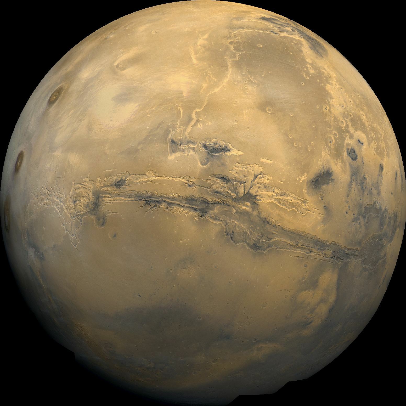
Explanation: The largest canyon in the Solar System cuts a wide swath across the face of Mars. Named Valles Marineris, the grand valley extends over 3,000 kilometers long, spans as much as 600 kilometers across, and delves as much as 8 kilometers deep. By comparison, the Earth's Grand Canyon in Arizona, USA is 800 kilometers long, 30 kilometers across, and 1.8 kilometers deep. The origin of the Valles Marineris remains unknown, although a leading hypothesis holds that it started as a crack billions of years ago as the planet cooled. Several geologic processes have been identified in the canyon. The above mosaic was created from over 100 images of Mars taken by Viking Orbiters in the 1970s.

I have always found this comparison infantile, especially when it is a guy (putatively) writing about Mars' canyon being bigger than our Canyon. Well, maybe juvenile. In any case,  confusing and unenlightening, like comparing feces with snot. 

(And wrong, too. HIS Grand Canyon is, in real units, 480 miles long, which is a stretch, and 18 across, although 12-15 is a more likely range, and mostly like 1.4 km deep. Was he using implants on the Canyon so we would not feel so inferior?)

And what is impressive about a canyon you cannot see? Not just because fewer people will get to visit Mars than get to run the Grand Canyon on their own. Look for instance at the ratio of depth to width (using apod numbers): On Mars, you have to look across 600 km for your 8 km down, or 1 down for 75 across; the Canyon is more like 1 down for 15 across. Now thats a gash. On Mars, well, look at it this way: If I put my head down on the curb out front (about 5"), and peer at the opposite curb 170" away, that is 1 down for ~37 across.  TWICE as impressive as the Mars Big One, that barely visual bump.  

Anyway, as everyone knows, of course canyons and mountains are bigger on Mars; the gravity is lower, so everything can swell up more.

Up Close: The Park's western boundary

I have written before about how GNCP's far western boundary came to be (entry of 9 Sep 2010), and the mapped result. The following piece of the official 1975 map shows the boundary as the dashed black line. I have added the red crosses and the blue numbers as aids for the discussion below.
On March 1-2, I was part of a boating trip that floated past this western boundary section, giving me a chance to think about a proper boundary as I was looking at where it would lie. What I hoped to see  were the landforms and their relationships, providing a view of how a defensible line would run. In summary, the boundary south of the river (1) showed up from the river as quite, and dramatically, clear. On the north side (2 & 3) the topography is not so emphatic.

Tuesday, March 22, 2011

The West End: Geology in action

February 25 through March 2, I had the great pleasure of floating down the last 51 miles of the Grand Canyon, something I did in 1966. I joined the end of a wonderful adventure run under the auspices of Dave Mortensen and Tom Martin that involved reincarnating, then rowing, three replicas of wooden dories first built and used in the 1950's, part of the amazing and inspiring history of individual exploration of the Canyon begun by Powell -- (and continuing today, even in the midst of the misguided NPS-comm-op management of river traffic). This contemporary adventure is being documented on 
http://historicriverboatsafloat.org/

Saturday, March 12, 2011

GC's National Monument # 2: Finally, Adulthood; 1939-40

Hayden and the Secretary met the next day, 8 Aug 1939, to discuss Roosevelt's veto of the long and labored attempt to set a boundary for the second Grand Canyon National Monument. 
An NPS briefing memo said there was little question of good timber; even grazing was scant. NPS, through Tillotson, had compromised with the local people, since the grazing side was favored and the land was not needed for Monument adminstration. Reporting on the meeting, the NPS said Ickes told Hayden "the President was too vitally interested in this matter for him to attempt to change his attitude". So they agreed NPS would go ahead and investigate it on the ground, the two then parting in the most friendly spirit. Hayden seemed to understand that NPS had done everything possible to effect the desired compromise. He later opined there would have to be more negotiation and then another bill introduced in January. 

Friday, March 11, 2011

GC's National Monument # 2: Groomed for Graduation, 1939

With the opening of the 76th Congress, Senator Hayden introduced S. 6 on 4 Jan 1939. He clearly aimed, after all the previous negotiations, for a resolution. The concept was very different; the lands kept would not be added to the Park, looking toward a time when all dams were built and a proper division could be made between Park and a reservoir recreation area.

These later files say that Hayden's aide Paul Roca actually handled all the discussions, and tended to the drafting of S.6, drawing the north boundary as agreed the year before (see previous entry). With the major players, including the several stockmen factions, placated, surely passage would be easy.