
For my purposes here, the Survey appears as a kind of butterfly flitting over the landscape and the issues, but in the end I have to turn back to the details to be excavated from the more mundane archives. It would seem that the Olcott report findings, as one example, would show up in the Survey, but that is rarely obvious. Maybe just too many layers of bureaucratic review had done their obscuring work. Nevertheless, a summary of how the Survey touched on the Canyon seems worth a few lines, always keeping in mind that the Survey was given life in response to Reclamation proposals.
There are five general chapters, e.g. geology, life, reservoir recreational benefits. The Grand Canyon gets a chapter and 20 pages, with Bridge Canyon Reservoir getting the most attention. Fifty pages go to Utah and Dinosaur NM. A final big section covers other Basin "recreational resources". Specifically, here is what the Summary (p. xxi) said about the Canyon:


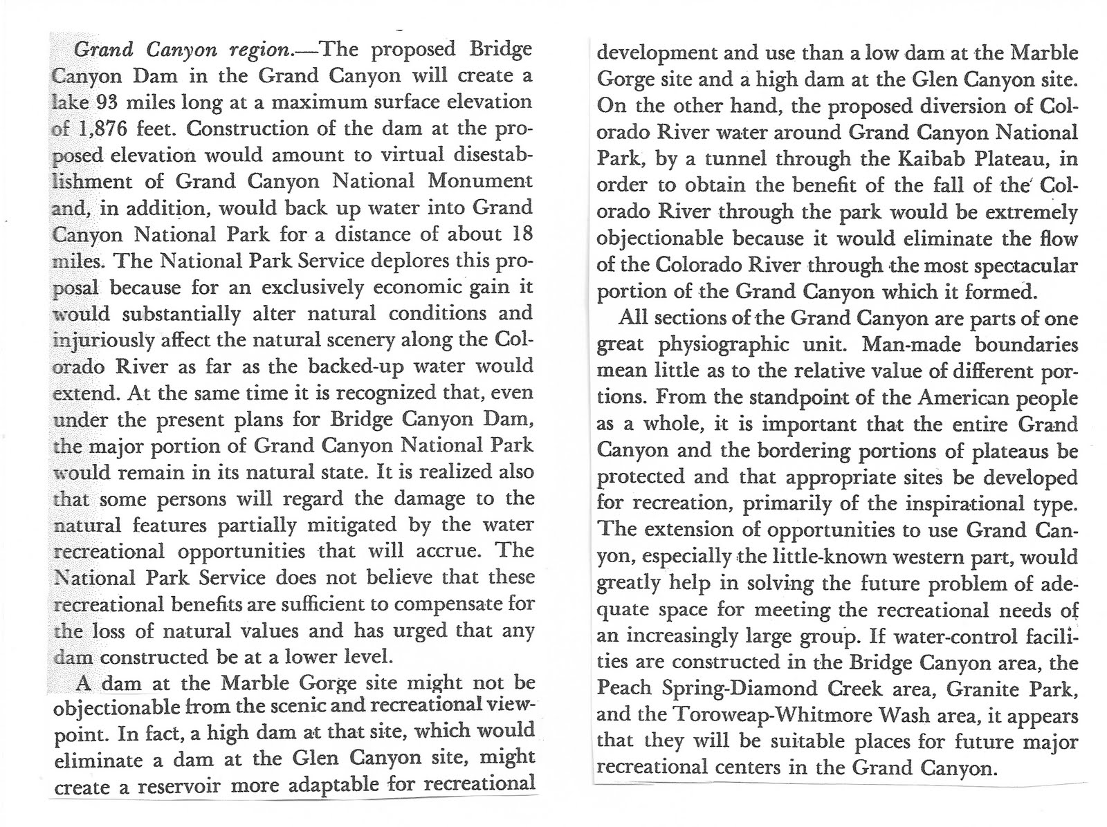
Remembering that this was written before the conservationist win to defeat a dam in Dinosaur NM, and over 20 years before the final fight over waterworks (any and all of them) in the Grand Canyon, is this a call to arms or an agreement to capitulate? Except for the final sentence (what are "water-control facilities"?), I could have written the third paragraph. So, having written it, why could NPS not see its way clear to calling for a more comprehensive, "complete" Grand Canyon National Park?
Later, on p. 41, the diversity in unity theme is struck again in juxtaposed descriptions of the eastern and western Canyon: "The significant point, therefore, concerning the Grand Canyon as a great spectacle with unusual inspirational value is that it is distinctly different in different parts, yet large and impressive throughout." And again, in writing about the lava flows: "above all, the complex interrelationship between erosion of the canyon on the one hand, and the piling up of volcanic matter on the other, make this area outstanding as a place for stimulating the mind". The Survey has two maps for the Grand Canyon; the first is the "region", plate 5:

Surely the most obvious aspect is that this is the complete ball of wax, the entire Grand Canyon, from its origin at the Paria, developing down through Marble Gorge, widening out into the restrictive Powell-Harrison concept, and on through the Monument section, to its grand finale swinging around the Shivwits. How could NPS make this map and ever doubt what the Grand Canyon is? Congress, thirty years later, finally laid all doubts. But in 1946, NPS had the words, had the map, and yet, along with its allies, lacked the political will and weight to push the full vision. What is on this map and the one below, plate 6 "Bridge Canyon Project Area", arises from Reclamation's vision, not NPS's.
The maps are worth picking over for the details, which taken together, chill the soul. Check out all the roads, like the one west of the Shivwits down Twin Springs Canyon to the reservoirs. Or the route of the Kanab tunnel. It would have been worse, of course; no powerlines are shown, no quarries or spoil dumps. And had this 1946 vision been realized then, shudder at all the industrial impacts the past two-thirds of a century would have brought. Grand Canyon Village and the Skywalk would have been pastoral in comparison.

As the Survey's Canyon chapter opens (p.128), the schizoid nature of this NPS debate over recreation and NPS organic values is brought right up: "Man-made boundaries … mean nothing as to the relative value of different portions. It is not possible to say that one part is either inferior or superior to another [(although Olcott had made such judgments, as had most investigators)], each is different but each is great and part of the whole." The very next sentence introduces the proposed dam. In the section of "suggestions for development", the Survey says: "the best use of the Grand Canyon area from the standpoint of the American people as a whole is to reserve and develop the entire canyon and bordering plateaus as a place for recreation, primarily of the inspirational type" (142). Even then (without our often-continuous air traffic), "the developed areas (are) so crowded and congested at certain seasons that chances for rest and contemplation are virtually nonexistent". The future relief, however, only comes "in connection with the recreational use of the proposed Bridge Canyon Reservoir".
Further on in the text, the Shivwits views are downgraded, just as Olcott had done, in comparison to those from the rim on the Hualapai Reservation (132). You can see on the map the boundary of the Recreation Area south of the Colorado taking ("overlaps" is the NPS word) some of the Reservation, an error many maps have perpetuated.
Though Bridge dam "may some day rise", along with Kanab and Marble, they "would completely change the natural conditions", harnessing the "thundering, heavily silt-laden" river "into a series of mill ponds" connected by "a clear stream". The arguments about impacts are familiar from the documents I described in earlier posts about dam debates, emphasizing that the Survey is a secondary volume, as well as a testament to the unresolved debate over NPS objectives.
The maps indicate the broad reach of this development for "inspiration". A northern highway could parallel the reservoirs, along with many, many spur roads to hard-to-reach viewpoints, and a Hualapai connection to Pierce Ferry. That road could be crossed by one connecting Highway 66 and St. George, also allowing a direct route from Phoenix to Bridge Canyon. The map does not even begin to show the major road and accommodation development on either side of the dam and at Granite Park. Toroweap-Whitmore would be a major attraction, with even more spur roads to observation points, and convenient lodges. All these would be in aid of an immense inrush of visitors. That is, having come to praise the inspirational values, they then want to bury them under the same congestion they found at the current Park. They talk of spots featuring a "peaceful, grassy meadow" or "nice growth of ponderosa"--only to cite them as great for campgrounds (147-7).
The irony of the unresolved debate is brought home in the last sentence: "If a road from Bridge Canyon Dam to St. George is not built, no development for recreational use of the Shivwits Plateau area is recommended. The present trails will suffice for those who wish to explore this remote area."
No comments:
Post a Comment