
The concept study of 1972(-4) was done by NPS staff, two from the Park, two from the Denver Service Center. In retrospect, it was a bold, forward-looking design that we Canyon advocates could have enthusiastically embraced and urged to fruition. Insofar as we pushed in the same directions, however, it was with different emphases, as I will discuss in the next entry. The Park Service itself did move the matter along, with some on-the-ground actions, and following its own procedural concerns. In 1973, NPS brought in the architectural, urban design and planning firm of ROMA, Rockrise Odermatt Mountjoy Amos, of San Franciscio. The Denver Center and ROMA contracted in June a Work Directive for the "comprehensive design of Grand Canyon Village, with Robert Odermatt being the principal for the work.
The introductory description said the work was the "beginning of a third phase" for planning and design of the South Rim developed area. Phase one prepared a master plan, along with wilderness and environmental impact studies. (Recall that NEPA was three years old, with the an initial period being spent on understanding what it required and establishing procedures. As a cutting edge weapon, it was in the process of being finely honed.)* Phase two brought the development concept plan and an environmental impact statement (EIS). The third task was to produce a comprehensive design for South Rim rehabilitation and development. It, too, would have phases, the first of which was to gain agreement and understanding on the broad planning concepts, and to obtain and analyze data for design alternatives. NPS would supply the data for ROMA to analyze the existing circulation and zoning, relating these to the environmental constraints. More than an inventory, a socio-economic structure and the political atmosphere would be identified. Finally, this phase would determine the "physical potentials", balancing functions, esthetics, and visitor desires to provide "a physical and emotional character in total harmony with the (NPS) objectives of this natural area".
The work under this contract was to be finished by October 1973. ROMA's data-gathering and analysis would use existing materials, and two trips to Denver. Visiting the Park was not mentioned. Clearly, this was a preliminary to any actual design work, and perhaps a validation process for the Development Concept report, completed but not yet approved. Certainly, ROMA came from a different orientation, having developed its services in "the design of civic, cultural, educational, commercial and industrial buildings and complexes; urban design projects in more than 20 cities; and community, industrial, recreational, and residential planning", according to the company brochure produced after it had started work at the Park. It had also consulted on Golden Gate NRA, and done planning for ski resorts. Not, therefore, a business with long-standing connections to the Park Service; perhaps that was the attraction.
Meanwhile, the Park administration was moving along a practical track, telling us in September 1973 of the coming start in April 1974 of a mini-bus system for the Village shuttles and West Rim Road. Private cars would be largely barred from the West Rim; otherwise, NPS was "hopeful" of people volunteering to use the shuttles, thus easing "traffic problems". Unlike the almost radical tone of the Concept document, this was all low-key and tentative; the service on the West Rim was called "experimental". Comments on the future of overnight facilities were bland. On the other hand, by August 1974, a writer in The Arizona Daily Star was amazed: the bus system had helped "get rid of" the litter problem. Traffic was definitely eased in the Village, the superintendent said, and praised the concessionaire for solving problems with visitor service. The air was not hazy.
However, the letting of the contract to ROMA had further stirred up suspicion, already aroused when some of us saw the inappropriate construction under Mission 66 auspices by South Rim concessionaires, especially Amfac (e.g. motels right on the rim; big asphalt parking lots; a super-market). So in early February 1974, John McComb (Sierra Club SW Rep.) and I visited Superintendent Stitt about NPS intentions. Then, having studied the contracts and related papers concerning the concessionaires and ROMA, we reported what was going on "to those concerned about Grand Canyon development plans".
First, we learned that concession contracts "require" money to be spent on construction and improvements, millions in the Village on visitor and employee accommodation and the new business center. Amfac was limited to 865 lodging rooms, however. More important to us, the completed Master Plan and Village Development Concept and their EIS's would soon be available and the subject of public meetings. After that would come a comprehensive design for the Village. ROMA's preparatory work was not quite done, so work directives for detailed plans were not available. We concluded there were no plans for significant new construction outside of developed areas. However, we were a bit naÏve there, not seeing that there might be places in the Village which we would become concerned about. As the EIS would point out, only 16% of the Village was developed. We ended by stressing the importance of the coming opportunity for public review.
In May, the Regional office released the draft EIS for the Development Concept, and in June, scheduled four public meetings on the documents, at which "all who are present and wish to make a statement (will) have had the opportunity to do so". (In today's buttoned-up and -down scenarios, there is no such forum for the public to make statements, which are part of a record, before the agency; now individuals can only come and chat with various staff who explain the "scope" of a proposed action.)
The EIS of the Concept summarized it as "maintaining the esthetic integrity of the immediate canyon rim", while separating areas for day use, overnight use, and residential and park support.(p.5) The interpretive zone on the rim will be buffered from the core village, and have only facilities for interpretation & visitor access, and historic buildings. The buffer will be undeveloped. The several maps of the Village in the EIS did not even extend so far north as to include Mather Point; all development was to be on existing impacted land. The three maps that follow come from the EIS, to show how existing area was to be used. First, as it was in 1972:

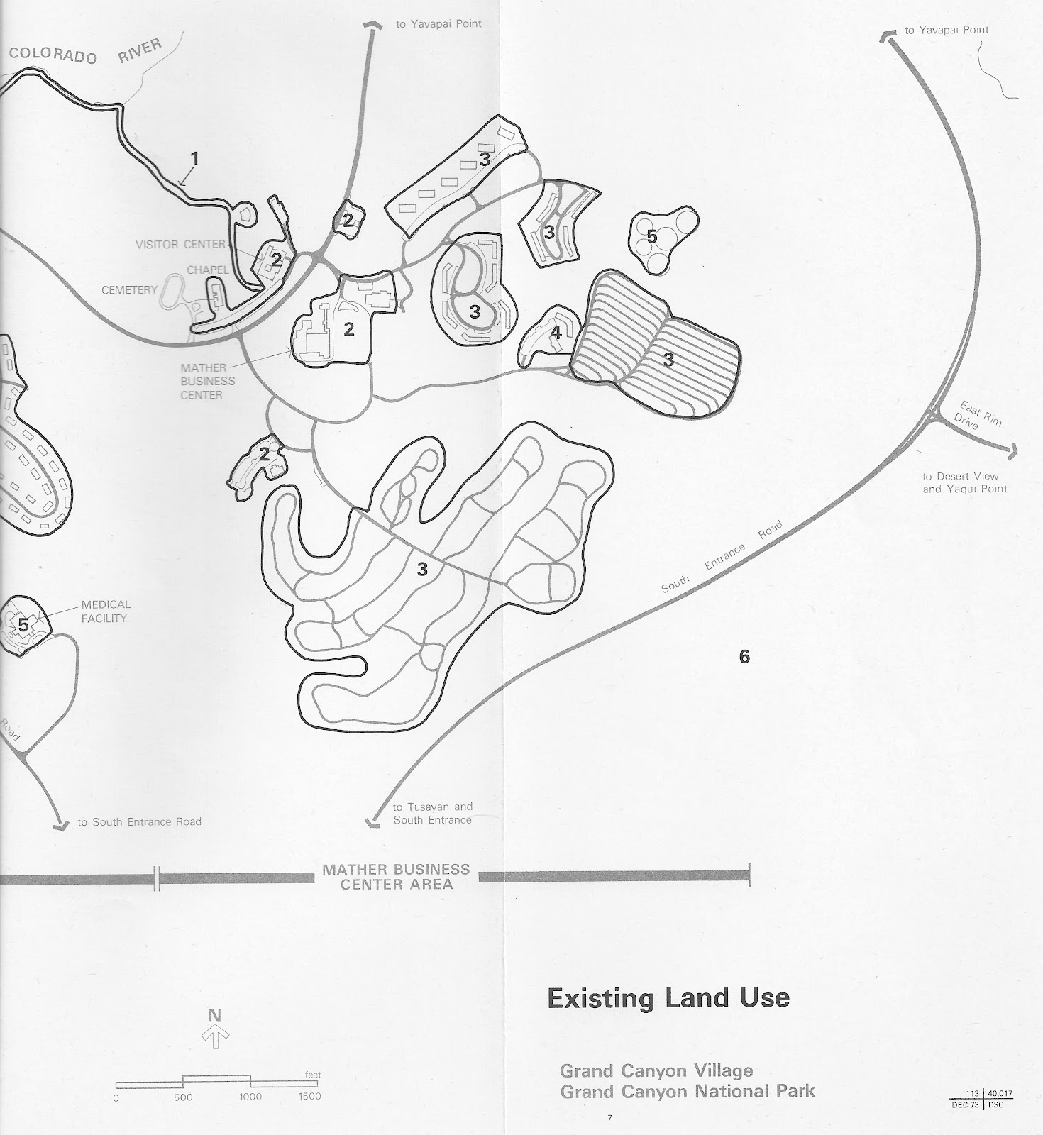
The numbers are 2 = Visitor Services; 3 = Visitor Accommodations; 4 = Residential Community;
5 = Park Support
5 = Park Support
Phase 2 would use the area marked by horizontal stripes for visitor services and parking, with a new access road from the south, and mass transit using the existing road to Yavapai:


Phase 3 would use a bit more of already impacted land, adding an "automated" transit route to Yavapai on the northwest, while keeping the buses on the east. Note that the campground was still shown, and even most of the motel units:


The big change brought by phase 2 was the building of the "proposed visitor-reception center" (p.11) with a "major parking lot" (p.9). The plan overall would "require massive reorganization" of the main Village, with "most existing structures … moved or eliminated" (p.9). The future bait-and-switch in Phase 2 was stated clearly: "a major visitor-reception center will be constructed east of the Mather Business Center "ON LAND NOW OCCUPIED BY THE TRAILER VILLAGE AND SIX ONE-STORY MOTEL UNITS OF THE YAVAPAI LODGE." (p12 & 15, my emphasis). Forty years later, and we can aptly say, "Promises, promises." Here, Googlemaps lets us see all the old development is still in place, with "Grand Canyon South Rim Visitor Center" occupying what was to be left alone:

Here is a later, 2011, Park Service photo looking southwest from over the Canyon, after the latest construction at Mather, with its intensified development. The storage tanks are as they were 40 years ago, anchoring the views & maps.

Anyway.
Back in 1974, the EIS of what was to be the guiding document said that it "assumes" that NPS would abandon trailer parks as "nonconforming uses" and the motel units, "built in the late 1950's, should be amortized sufficiently by the end of this phase (2, well before the year 2000) to make their removal economically feasible".(p.15) The reception center would provide "information and unspecified services (at the) mass-transit terminal". An integrated, pedestrian-oriented village center would be developed south of where the railroad yard was. New lodging west of that would replace (amortized) units removed elsewhere. In Phase 3, the rim zone would be cleared of such nonhistoric facilities as the Bright Angel, Kachina, & Thunderbird lodge/motels and all parking & roads.(p.16) "El Tovar will remain as a conspicuous feature in this zone, but presumably will not be used for overnight accommodations, dining, or other visitor services." Also promised: "a significant portion of lands (in development zones) will be allocated to open space and natural buffers".(p.18)
The existing Village "sprawled over the landscape", reflecting "dependency on the private automobile", with "facilities that have become nonessential or obsolete (consuming) valuable space". The Concept envisioned mass transit replacing the car, but the ultimate nature of the new system was not specified because "no one knows what technology will be available" in 2000. [Nor, as we learn from Brad Traver's narrative (my entry of 10 Oct 2011), did they know about Republican obstruction.] However, during phase 2, the reception center would be built on about 30 acres of the trailer village site, including parking for 3,000 cars, reachable by a new 1½-mile road. The mass transit system would completely eliminate the car in phase 3, perhaps becoming a fully automated driverless system. There would be two loops from reception, one to Yavapai Point for interpretation, the other circling about in the Village.
The Concept does provide some insight on the interests that could, and would, influence NPS decision-making on its radical reorganization of the south entry and Village facilities. Not only did it contemplate removing the trailer park and amortized motel units, it also proposed eliminating Mather Campground. Had these sites been cleared and the car bar implemented, the pressures for replacement development on Kaibab Forest to the south, as well as the tourist nexus developing at Tusayan, would have escalated. Active, too, was a proposal for a large-scale motel/campground four miles west of Tusayan, perhaps bringing pressure for paving the Rowe Well road. At that time, water was trucked in 60 miles, and providing water from the Park was frowned upon. Today, deep wells provide water, and Tusayan has grown, even without the closures the Concept called for. Also the owner of the Orphan Mine on the rim two miles west of the Village center still had the right (until 1987) and hope of taking out more uranium. That potentially messy outcome did not materialize. As the report said, extraction was then "economically feasible" (i.e., the price was up), a condition that did not persist.
The draft EIS has the value of serving as a snapshot in words of the Village, its infrastructure and activity, at a moment when values had indeed shifted, from being demand-friendly, toward a public and agency reassertion of Park System fundamentals. As it turned out, existing facilities and interests both would hinder and trip up that shift.
Other issues: Although the EIS said there were no "unusual" plant communities or species, what did became important in discussions was the ponderosa pine belt along the railroad line (p.32). "Grand Canyon Village is not a quiet place, nor is the park as a whole.(p.43) Noise sources were few, but pervasive: a generating station at Hermit's Rest, motorcycles, and aircraft, the last of which could be heard almost continuously from, in order, helicopters, tour & private planes, high-up jets. The numbers of overnight units seem small in comparison to the day visitation: 325 campsites, 863 rooms, 193 trailer sites, compared to 2-4,000 vehicles on a summer day. Under the plan, the capacity for day use would increase significantly compared to a decrease in overnight spaces (p.92). This would emphasize the quick-look experience 75% of visitors had, as against a longer immersion, which itself was perhaps a left-over from a time of slower travel. Perhaps a more apt comparison would be of the longer-stay visits in the Village with those below the rim -- hikers, backpackers, river-runners. Certainly, our concern was the pointed one of removing obstructions to a natural context for a satisfying "first look". Get us out of our cars, we say, and point the way to the rim, preferably through a bit of forest and so we can hear the breezes. The Concept emphasized that the putatively undesirable impact of building a 30-acre lot to leave our cars would be on land converted from already built-upon ground.
After going through the standard sections on impacts and their mitigation, the Concept EIS took up alternatives. It dwelt on an "interpretive" alternative of rail service along the Santa Fe tracks, with a parking lot in or near Tusayan. More conventional was the idea of re-starting Santa Fe passenger service. Also considered was a brand-new "bypass" of the East Rim road, but it was deemed wasteful and destructive. The concept of mass transit loops required more construction, but was still preferred over keeping a two-way road. Perhaps sensing that NPS determination to close the trailer park was not solid, the Concept considered putting the reception and parking area southeast of the East Rim and South Entrance road junction, on a site that "has been burned over and contains regrowth vegetation of less esthetic value than the mature ponderosa pines, pinyon pines, and junipers that will have to be cleared to permit construction…near the trailer village."(p.119) This could be done right away, though there would be an increase in operational costs. Or, was the next suggestion, go even farther, and put the "major staging area" at Tusayan (p.120). The operational costs would be even higher, and NPS control less. There would be various inconveniences, but Tusayan interests would be happier. So that idea was put out there, but the debate over parking-lot placement was barely begun. Other ideas of moving overnight and residential units here or there or out of the Park were dead on arrival. What the Concept had achieved, then, was to confront the car, and declare it non grata in its current buzzing, booming traffic chaos. The question not decided: What to do with it?
*The materials for these posts come from my files collected during the time. This contrasts with others of my blog posts in which I researched Park Service and other agency archives. Consequently, this story is limited by, and slanted toward, my experiences during the planning process.
For me, John McComb (my successor as the Sierra Club Southwest Representative), and other Arizona-based advocates for the Canyon, that process had started in the late 1960's as the dam fight was reaching its end. The local Club chapter had worked with me on our own master plan concept and document, along with wilderness and park expansion studies. While we did not command the technical expertise of NPS planners or ROMA, we were therefore deeply familiar as Canyon users and would-be protectors, in many cases with more Canyon experience than involved NPS or other personnel.
The 1960's & 70's were, unlike today, a charged time for environmental work and public involvement in governmental activities. Not only were new rules being written and tested out, but government staff were far more open and cooperative. The ossification, self-protectiveness, and impenetrability of today's environmental and land-use agencies and other entities is a sad comment on the bureaucratization of what, 30-40 years ago, was a process full of active interchange and some optimism. Although, as I often feel the need to comment, we did get frustrated now and then.
No comments:
Post a Comment