
Due on 3 Jan 1976, the Secretary's findings & recommendation were contained in the report dated Nov 1975. Copies were distributed to the public in February. These came in the form of ordinary stapled paper report by NPS; the fancy leather-bound presentation copies were for Congress.
The cover letter to Congress, 23 Jan 1976, was signed by Ass't Secretary Nathaniel Reed, and made three major points:
1. Significant archeological resources, possessing exceptional value, may exist bringing information on the movement of prehistoric people, their changing lifestyles, and other unresolved problems.
2. Geologically, there were ancient drainage patterns on the Kanab Plateau that could lead to better understanding of the Grand Canyon's formation. Biologically, the communities would help in interpretation, as control areas for evaluating changes from human activities, and in analyzing the environment of prehistoric cultures.
3. Scenically, there is a sense of spaciousness in the sweeping plateau lands through which the Colorado has cut the Canyon, lending diversity to visitors' viewing experience.
Furthermore, the areas could only benefit the local economy marginally in grazing, logging, & hunting activities.
The study concluded that the lands therefore are "not 'unsuitable for park purposes'", and ought to be retained within the Park.
A good sign, the Park Suitability Study document opened by quoting section 2 of the new Act recognizing the "national and international significance" of the "entire Grand Canyon" including "surrounding plateaus".
It then went over the checkered history of the Monument's northern boundary -- generously established in 1932, brought south in 1940, proposed to be brought closer to canyon rims as late as the 1971 Park Master Plan draft, a proposal embedded in Goldwater's Park bill of 1973. Three areas would have to be taken out of the Park System: Tuckup Point of 23,700 ac., Jensen Tank, 9,000 ac., & Slide Mountain, 5,380 ac. The reasons for taking the lands out of the Park System were that they were not needed for resource protection, they were better suited for grazing, and they could be used for land exchange.
That position, however, was reversed by NPS in the 1974 Plan draft, which argued that reversal was justified by the lack of need for exchange and the discovery of rich, unexplored archeological resources that could provide "data of incalculable value" on the westward expansion, and later withdrawal, of the Kayenta Anasazi. However, hunting and ranching interests claimed those resources could be protected under multiple-use administration as public lands. The compromise reached was to keep the lands in the expanded Park and then study them to see if they were "unsuitable" for Park status.
The study had to determine if the areas were of national significance and met NPS standards of being suitable. The criteria were somewhat abstract: "exceptional value… in interpreting (our) national heritage"; "a true, accurate, essentially unspoiled natural" locality; "relatively spacious"; "sufficiently comprehensive (for) public use and effective management"; "a diversity of resources, … including scenic and scientific". It was clear that the areas' context of being associated with the Grand Canyon, its canyons and plateaus, was crucial.
After a brief statement about the region, the detailed description started with the "most distinctive and most variable" area, Slide Mountain, part of the Pine Mountains (Uinkaret),
the long volcanic ridge of cinder cones and basalt active in the last 1¼ million years.
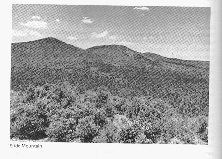
Out from the east side, a lava "cascade" descends between two Kaibab point to Tororweap Valley. (This is only one of the many volcanic events marking the Uinkaret and integral to the Canyon's geology--much of which we had tried, and failed, to get added to the Park.) The piñon-juniper are penetrated by ponderosa from the south. Lower, sage dominates.
Tuckup and Jensen are both relatively low-relief surfaces of Kaibab limestone, the first containing "an ideal example" of piñon-juniper forest, the second preponderantly sagebrush that shows a distinct ecological variation in the frequency of its cover.
Evidences of human settlement from about 100 A.D. until the XIIth Century were of a farming economy, with ties to the Kayenta Anasazi on the east side of the Colorado. [Later work in this region has refined or even re-defined this formulation by R A Thompson.]
Next appeared in the region the completely unrelated Southern Paiute, semi-nomadic, a gathering-hunting economy. They have left no evidences in the study areas, apparently therefore of little interest to humans until Mormon ranchers and farmers began utilizing the areas in the XIXth Century.
The Mormons put a sawmill on Mt. Trumbull north of Slide, and ran cattle, especially using Jensen and Tuckup for winter range. Cattle-raising continued after the sawmill (used to produce lumber for the St. George temple) was shut down. The Schmutzes are mentioned as a "prominent ranching family", since they used Tuckup for winter range from 1897. Only a few years later came the sheepmen. Tuckup and Jensen offered excellent winter range for the sheep if there was snow, making part of a circular route through the Arizona Strip. The inevitable battles over water rights and range condition led to the end of open range after 1934 and the establishment of grazing allotments. Poor markets and "predation" caused a decline in sheep use until in 1964 there was only one small herd on Tuckup, finally leaving only cattle. "Evidences of the intense grazing pressure … are healing".
Homesteading and dry-land farming were tried in the Toroweap area in the early XXth century, but there was too little water. The only evidences left from whitefolks' activities in the three areas are from grazing.
In 1975, these areas were "the most isolated and least visited" plateau lands in the Park. Instead most see them as distant horizons or silhouetted canyon edges. A few fly out from Toroweap after a river trip. A very few. For those who choose camping in primitive conditions, there are spaciousness and solitude. Deer & turkey hunters come seasonally to land adjacent to the Park. Lack of water inhibits almost all use. There are dirt tracks to any trailheads or overlooks, emphasizing the areas as primitive alternatives to the North & South Rim Park areas.
In 1975, only two permittees were left of the dozen or so given lifetime privileges after the Monument was established in 1932. They were running perhaps 200 head all year or seasonally.
Hunting, of course, is not mentioned under existing uses, but game was evaluated in the next, and main, section, Resource Analysis.
Analysis of the geology emphasized Toroweap Valley & Fault as a divide between the Kanab Plateau on the east, a block plateau showing the sedimentary layers familiar from the old Park area, but faulted so that the Esplanade is easily accessible. On the Uinkaret, the lava flows and cinder cones have been superimposed and the Valley is floored with lava from three recent (Pleistocene/Quaternary) volcanic episodes, correlated with activity along the Toroweap Fault and the Hurricane Fault on the western side. [Irrelevant for this report, the question of integrating the interpretation of the evidences of this volcanic action on the Canyon, raised by our attempt to include the Whitmore area in the Park, would be germane to the Adjacent Lands study.]
The evaluation of this geology pointed out that the Slide Mountain lava was the oldest in this section of the Canyon, while in the other two areas, intricate drainage patterns that appear to go nowhere might provide information on the Canyon's formation. Grazing developments could alter this topographical evidence.
Biologically the cold temperate desert conditions of the area -- hot during the growing season, low precipitation, poor moisture-holding capacity -- produce the dominant piñon-juniper forest with some desertscrub and ponderosa. Aggressive invasion (e.g. cheatgrass) common elsewhere is "very slowly" being reversed in some instances by natural succession. The small ponderosa patch has very old and young trees; middle-aged trees having been cut a century before. There were no rare or endangered species encountered. The abundant mule deer around Slide Mtn. are part of the herd resident on Mt. Trumbull to the north. There was little evidence of deer on Jensen or Tuckup, perhaps because of the lack of free water. There are turkeys, but they are transplants.
The evaluation said that while the biological communities met some criteria for NPS natural areas, they were adequately represented elsewhere. Nevertheless, in the interpretation of the Grand Canyon, they provide context for understanding the complex, that is, the entire Canyon is greater than the sum of its parts. Moreover, once gone, they will not be replaced, and are valuable for their baseline information. They are small compared to the entire Strip, but are more significant as unmanipulated acreage, without the chaining, railing, burning, herbicides, and heavy grazing most of the Strip has seen. They may also be crucial in understanding the life of previous human communities.
Archeological work showed the Anasazi left evidences of both permanent habitation and seasonal nonagricultural uses. The visible ruins suggest semi-subterranean pit houses or storage cists.

They were found near building material and arable land. On the Esplanade, there were large pits for agave roasting. In two side canyons, rock art was fairly common in the inner gorges.
The evaluation of the archeology predicted over 3000 sites on the three areas, a block of territory that has enjoyed considerable protection, and that contains clues to a settled way of life that persisted for over a millennium. There should also be information on the transitions from hunting-gathering to settlements, and then a reversal of that change. New data may affect the account of the sequence of structural forms. The site density is exceptional, with good collections that should present a more accurate picture of population increase. A crucial question that needed answering is where the water for personal & household use came from.
This was not an isolated backwater [as it is now, the writer might have added]; the people here were a stable part of a cultural continuum that linked into the entire Southwest. The area is not well known archeologically, but its significance may surpass others parts of the Park. [This prediction, or hope, has apparently not come to pass; it is not clear how much work Thompson or anyone else has done in the past 40 years.] The missions of NPS and BLM are compared, and although not critical of BLM, the Study concludes that NPS can more effectively investigate and protect over the long run whatever archeology can produce.
The last NPS resource was "Scenic Grandeur".

The report correctly started by stating the areas are "part of the vast plateau lands from which the Grand Canyon is derived". The flat, vegetated plain contrasts sharply with the more barren vertical canyons. The visual impact for the traveler is heightened by the abrupt show of the canyon after the miles of plateau. Each of the four plateaus now represented in the Park (the Shivwits and Hualapai being left out) is distinctive. Kanab affords views of the western Canyon and, dramatically, of the Esplanade. Its few high points orient the visitor to regional features as well. The Uinkaret with its higher elevations, present significant views of the entire region. They also provide a sunset backdrop for views from the south rim. Altogether, they lend diversity to the visitor experience, emphasizing spaciousness and isolation for this Canyon backcountry. Slide Mountain is visually an integral part of Toroweap Valley, a primary access to the mid-Canyon.
Switching to alternative uses the areas might be put to if not in the Park, comparison is made with the Arizona Strip west of Kanab Creek. Mining potential is zero. Logging could only be done on spots in a 285-acre southern section, an isolated pocket of extremely marginal potential. The quality is low in this overmature decadent stand, and reproduction is sparse. The average age is over 200 years. Were there to be sustained-yield logging, the harvest of about 600 thousand board feet could not be considered economical.
Grazing was considered historically and theoretically, taking into account various elements of management, including vegetative manipulation. At best, the areas could add 2-3% to what the entire Strip produces; with the more drastic methods, maybe a few percent more. However, in any case, information is lacking on the long-range outlook.
Hunting had special significance, since its advocates had been instrumental in opposing Park expansion on the north side. The report accepted that it was the primary recreational use of the Strip. The Uinkaret has a substantial population of mule deer, and turkeys have been introduced. BLM contends that NPS management in the old Monument was detrimental to wildlife "production". BLM would like to carry out activities to increase deer population, indicating the basic difference between the two agencies' philosophies. Were there to be hunting in Slide, another 50 might be shot in addition to the 378 taken in 1974 in the entire Game Unit 13, gratifying perhaps 170 hunters. Economically, this is of little account.
The Conclusion (p. 49-50) is emphatic: "The analysis …clearly establishes that the lands … are suitable to continue to be used for park purposes and that the public interest is best served by the retention of these lands within Grand Canyon National Park."
The major supporting points were the national significance of the archeological resources, the geology of the drainage patterns on Jensen and Tuckup, the biological communities in that they support the integrity of the Canyon context, the diversity of the scenic qualities, and the marginal benefits from their being put to other uses. Deletion of these lands would make the management of the rest of the plateau land too difficult and more costly to NPS.
Source: "Park Suitability Study Grand Canyon National Park / Arizona",
The Department of the Interior / National Park Service, February 1976
No comments:
Post a Comment