
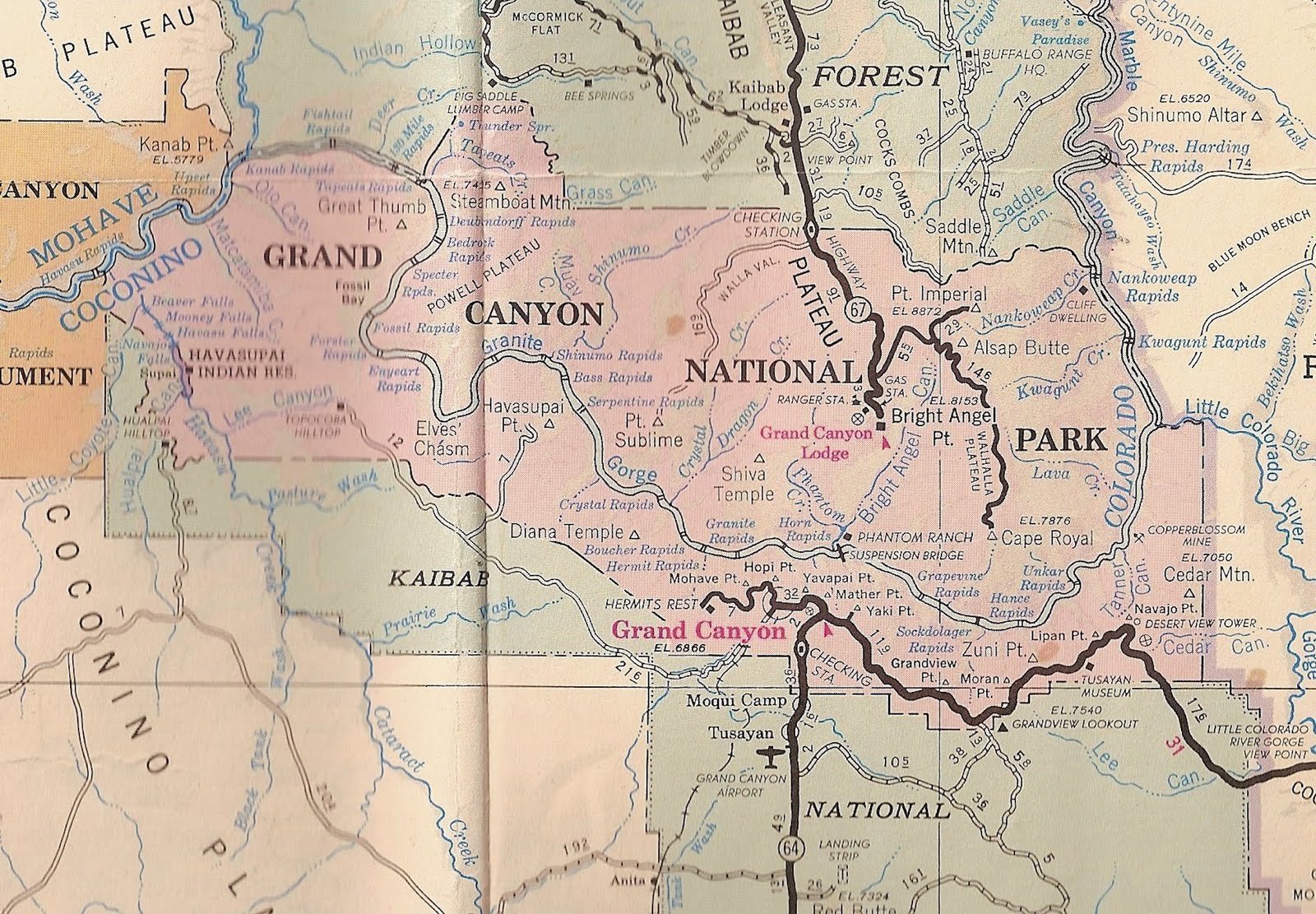
Segment D of the Park boundary is shared with the Tusayan district of the Kaibab National Forest. In 1908, when the first GCNM was proclaimed, the Forest was the Coconino; the name was soon changed to Tusayan NF in a boundary change, and still later was combined with the Kaibab north of the Canyon, as it remains today.
Segment D can be considered in two parts: On the east, it follows section lines; on the west, it had a more interesting career. Here is how the GCNM boundary appeared in the years after 1908 as GCNP legislation began its decade-long trek through Congress:


(The dashed and diagonal lines are not relevant here. Also, the western end is truncated because in 1975 that section of the Park and Forest was repatriated to the Havasuapai.)
The issues as the Arizona delegation and the Park Service wrestled over sections and fractions of sections were 1. to give the Park and businesses like Fred Harvey Co. room inside the boundary for development: roads, administration buildings, hotels, etc; and 2. to take no land or waters that the local stockmen or forest rangers claimed they needed.
Here is the result as the GCNP was signed into existence in February 1919:

The squeeze toward the rim was noticeable in the southernmost part; the big add was in the vicinity of Grand Canyon Village (toward which the Santa Fe line is shown). I have only drawn in the western section of this segment approximately since it lasted but 8 years and was described this way:
"thence northwesterly along the southwesterly side of said Tobocobya Spring-Rowe Well Road,
passing and in relation to United States Geological Survey benchmarks stamped "Canyon" and numbered 6340, 6235, 6372, 6412, 6302, 6144, and 6129". Wars are started over language like this.
The next step came in 1927, as a result of Mather and NPS wanting to make additions to the Park on the north and south, a story I have not yet told. NPS had been administering the Park for a few years. It was particularly interested in roads, including a paved touring road from Park h.q. to Havasu Canyon. This led to the following recommendation:

The 1919 description using USGS benchmarks was changed to read:
"thence northerly along west line of section 36, township 31 north, range 1 east, to a point one-
half mile south of the center line of the Supai road survey as mapped and staked by the Bureau of Public Roads during the field season of 1925; thence in a northwesterly direction following a line, which maintains a uniform distance one-half mile south and west of the center line of said road survey, to its intersection with the projected section line between what probably will be when surveyed sections 9 and 16, township 32 north, range 2 west; ".
The effect was to bring that western part of Segment D closer to the rim.
At the Park's eastern corner, the 1927 Act added several sections, squaring it off. Management reasons were cited, though there was concern about the presence of Navajo and their sheep.
I have placed two red dashes on the map. The left-most indicates where the 1975 Havasupai boundary will come up to the GCNP boundary on the east. The other red mark points to a barely noticeable addition described as:
hence westerly along section lines to a point nine hundred and fifty feet west of the northeast
corner of section 22, said township; thence due south a distance of one thousand three hundred and twenty feet to a point on the south line of the north tier of forties of said section 22, thence westerly...
Road and entry control were the reasons for adding these sections in the center.
Not satisfied, a year later, March 1928, Congress added 48.79 acres to the Park in that obscure corner, extending the boundary east so that it ran
"west between sections 14 and 23 of T30N, R4E, to a point 660' east of the northwest corner of that 23, then south a distance of 1,320' (one row of sections) to the south line of the north tier of forties of that 23; then west".
(And, for what its worth, in 1957, GCNP proposed adding the remaining three-fourths of section 22. By the time enlargement came in 1975, that addition had been dropped.)
Here is a map of the resulting 1928-75 GCNP, part of the "Indian Country" map from those fine cartographers of the West, the Automobile Club of Southern California. Segment D of the boundary ends just at the fold line. Rightwards of the fold, the map shows how the current boundary retains some of that line so oddly referenced in GCNP legislation to a "road survey".
Even more detail shows on the BLM Arizona Strip map of this segment, bumping along
"a uniform distance one-half mile south and west of the center line of said road survey". I suppose this was all long ago surveyed out and fenced, and there are no arguments between the agencies, given that the grand Supai motor road NPS planned to Havasu Canyon was never built. Certainly this BLM map does not seem to match the legislation's words.

We are not quite done. Sometime after the 1927-8 legislation, the Park Service needed another little piece of the Forest, and embedded it in a proposal introduced in 1957 by Senators Goldwater and Hayden. This was labelled the "Coconino Plateau" addition and did in fact get included on the map that established the GCNP boundary in the 1975 Enlargement Act. The land added was the north halves of sections 7, 8 and 9 of T30N, R5E. Here is the official map (look in the lower right):
(UGH. I MISMEASURED AND PUT IN TWO SECTIONS. NOW CORRECTED 9/10/10)
(UGH. I MISMEASURED AND PUT IN TWO SECTIONS. NOW CORRECTED 9/10/10)
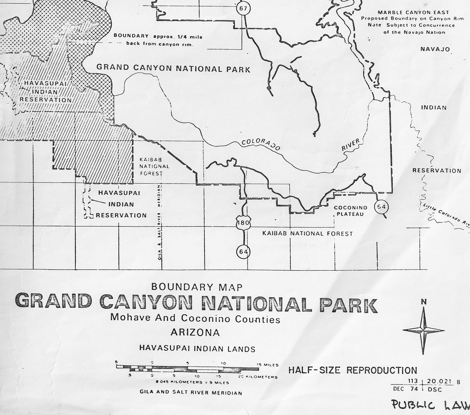
(Here's another oddity; the BLM and 2002 AAA maps for that section of the boundary show those three half-sections still in the Forest. Correction: the 2006 BLM now shows the three in the Park. )
So now, in a final exam, I will attempt to describe (less obscurely?) Segment D of GNCP, running from the Navajo to the Havasupai Reservations:
Starting at the southeast corner of section 5, T30N, R6E (= se cor 5, 6E 30);
(THE FOLLOWING THREE LINES ARE CORRECTED, 9/10/10; minus 5 points on my test)
(THE FOLLOWING THREE LINES ARE CORRECTED, 9/10/10; minus 5 points on my test)
west 5 sections to ne cor sec 9, 5E 30;
south ½ mile to the se cor of the north half of that 9;
west 3 to the sw cor of the north half of 7, 5E 30;
Then, all in 4E 30,
south ½ to se cor section 12;
west 1 to sw cor that 12;
south 1 to se cor 14;
west on section line to a point 660' east of nw cor 23;
south 1,320' to a point on the south line of the north tier of forties of that 23;
west to section line between that 22 and 21;
south to se cor 21;
west 3 sections to sw cor 19;
north 1 to nw cor 19.
Then
west 2 to sw cor 14, 3E 30;
north 1 to nw cor that 14;
west 5 to 12, 2 E 30;
north 2 to nw cor 1, 2E 30;
west 6 to sw cor 36, 1E 31;
north about 1-½ on west line of that 36
to a point ½ mile south of the center line of the Supai road survey as mapped and staked by the Bureau of Public Roads during the field season of 1925 [comment: surely, after 80 years, this is now a line surveyed, marked, and fenced; as is the boundary going] in a northwesterly direction following a line which maintains a uniform distance ½ mile south and west of said center line, to its meeting with the Havasupai Reservation boundary as described in the 1975 P.L. 93-620 (and in my following post on Segment E).
Sources: For legislation: http://codes.lp.findlaw.com/uscode/16/1/XXIV
Otherwise in my files, and AC of So Cal & BLM as cited.
No comments:
Post a Comment