
1998: Before the News
Having the time to become once again involved in matters affecting the Grand Canyon, In 1998, I attempted to grasp the threads of affairs I had dropped 16 years before, even though few of the players I had known were still around. Particularly with respect to the park-worthy areas of the Canyon’s north side, the issues unresolved in the early ’80’s were handles I could grab in seeking to learn about a new status quo.
I wrote letters to agency heads, sought conversation with them and with active environmentalists, and planned reconnoitering trips, particularly to the Arizona Strip. My timing on the latter was fortuitous, since as I was traveling, Secretary Babbitt was putting together, at his much higher level, his ideas about more Antiquities Act actions. Of course, I had no knowledge of his moves, and the Arizona Strip BLM staff that I interviewed said nothing. Unlike my efforts in the 1970’s, I was now an unfamiliar inquirer with no organizational connections.
My first efforts were letters to Lake Mead NRA and the BLM Arizona Strip office, asking about activities that had seemed important in the 1970’s decision not to extend GNCP boundaries to include the areas from Whitmore over to the Shivwits: grazing, visitor use and road conditions, hunting. The one aspect that seemed to have changed was that grazing on parts of the NRA was being eliminated, and some of the private lands had been traded out. The Parashant uranium prospecting scare of the 1970’s had not repeated, the miners’ action being concentrated to the east near Kanab Canyon.
In September, as I was planning an October trip, I concluded from my long distance inquiries there had been changes in administration and activity to strengthen what I wanted to think of as a Grand Canyon Environmental Area — a descendant I suppose of the “protective” zone we had promoted and then abandoned in 1972-3. Federal lands relevant to the Canyon were being consolidated, grazing fading. People were concerned with issues like the condor introduction, and restricting the impacts of uranium mining. Low use recreation was primary, and trophy deer hunting was still very active — permits had tripled, though only 3% of applications.
Strong was the recognition and desire for the Arizona Strip to be seen as isolated and left “as it is”, even as visitation from outside was promoted.
Any time spent wandering the Strip is rewarding. Setting out on my expedition, I did find that after decades of driving a high-clearance but underpowered (& not-always reliable) VW bus, its replacement by an Accord was not the best change in back-country vehicles. Still, I was able to get into Hack Canyon to see the reclaimed mine, and the ready-for-action Arizona 1 mine up above. The broad approach down Toroweap was still — 70 years after it prompted NPS to have President Hoover declare the second GCNM — a splendid, unspoiled, impressive entry to the middle of the Canyon and its volcanic history. It was satisfying to come back to John Riffey territory, and find that NPS needed three to replace him. The patchwork of administrative jurisdictions covering the Canyon’s north side still seemed wasteful, denying to the public traveling through the Canyon’s hinterland an integrated welcome and presentation of the Canyon’s extent and impact. In summing up my talk with the BLM staff, I was much impressed by the many pro-Grand Canyon actions.
Babbitt’s Initiative Announced
My getting refamiliarized with the Arizona Strip was, entirely coincidentally, taking place as Interior Secretary Babbitt was directing his staff to get ready for some sort of protective action focussing on Canyon lands north of the National Park, west from Toroweap. In late November 1998, Babbitt brought a bunch of officials along with the media onto the lands of a “Proposed Shivwits Plateau National Monument” as the map in the Arizona Republic had it in the 27 Nov article by Steve Yozwiak, “To keep it wild; Babbitt has plan for 400,000 acres north of Canyon”. This map, a sketchier version of the one BLM produced (see below) also inlcuded townships in 13W and 14W that are topographically west of the Shivwits Plateau and do not drain into the Grand Canyon.

The “Republic” article set the proposal in “some of the most isolated, mysterious and surprisingly beautiful land in the Southwest, settled by Mormon pioneer ranchers and coveted by hunters for trophy mule deer.” The proposal includes “reaches of the Grand Canyon” not in the National Park, with only a passing reference to the Shivwits being “a band of Paiute Indians”, instead of noting their long-time residence there. Development pressures include uranium & copper mining, housing subdivisions, and “wildcat roadways carved by off-highway vehicles.” Babbitt called it “the most pristine rim area in the entire Grand Canyon system”, and he wanted to protect it before “the problems are on you, then you have controversy.”
Babbitt included on the trip his top assistants, regional land administrators (GCNP & LMNRA Sup’ts & BLM Arizona Strip Manager), and “some of the nation’s leading conservationists”. He stressed the need to look 50-100 years ahead, think carefully about long-term management for our heritage. He wanted to avoid backlash like that after the surprise of the Grand Staircase - Escalante NM announcement. He would talk with ranchers, hunters and the Arizona delegation to build a consensus, though they were not invited on this trip. Babbitt said he was open to wide-ranging discussion, though legislation had not been easy to come by in the last six years. With only two years left, his time is running out. He spoke about grasslands restoration efforts. He did not want to expand the National Park, since that would end hunting and ranching, he said, destroying some of the area’s cultural values.
Yozwiak quoted Tony Heaton, owner of a homestead in Whitmore Wash from which he ran 600 cattle in the Canyon and fetched 10,000 river passengers from Hualapai land to his dude ranch: “Sounds like a land grab…enlarging the Grand Canyon National Park…The whole Arizona Strip is a place we love…We don’t need the government to close it up”. Comments from the Bundy family and others showed their worry about effects on ranching, mining, logging & oil drilling from actions like the Grand Staircase proclamation. Discussion by Babbitt with hunters and ranchers about what he was considering would ease the way.
On his trip, Babbitt admired the “great, long mesas running all the way out above the river, colorful side canyons, pine forests, the way the land kind of drapes down off these rims.” The Strip’s BLM manager claimed “not a week goes by without calls from real-estate speculators.” The area is only a few hours drive, a short air hop, from Las Vegas. Two conservationists from the National Trust for Historic Preservation and the National Parks & Conservation Association were in favor of quick action. Those focussing on wildlife hoped to protect and restore native biodiversity and the ecological richness of this whole area. The Grand Canyon Wildlands Council and Grand Canyon Trust hoped a designation could connect fragmented jurisdictions to provide consistent conservation management and restoration of wildness and healthy ecosystems.
In this map, the Arizona Strip office of BLM refined the boundary to carry out Babbitt’s concept of including all the Canyon’s watershed west from the Toroweap drainage of the middle Canyon.

Note that this (undated) version extended beyond that watershed to include lands in townships 14W and 15W that went over and down the Grand Wash Cliffs. This is shown more clearly in this BLM field office map issued when the Secretary closed the target area to location & entry as “Segregated Public Lands”. (I was told that the withdrawal from mining entry had been done two years before, but I have not verified that):
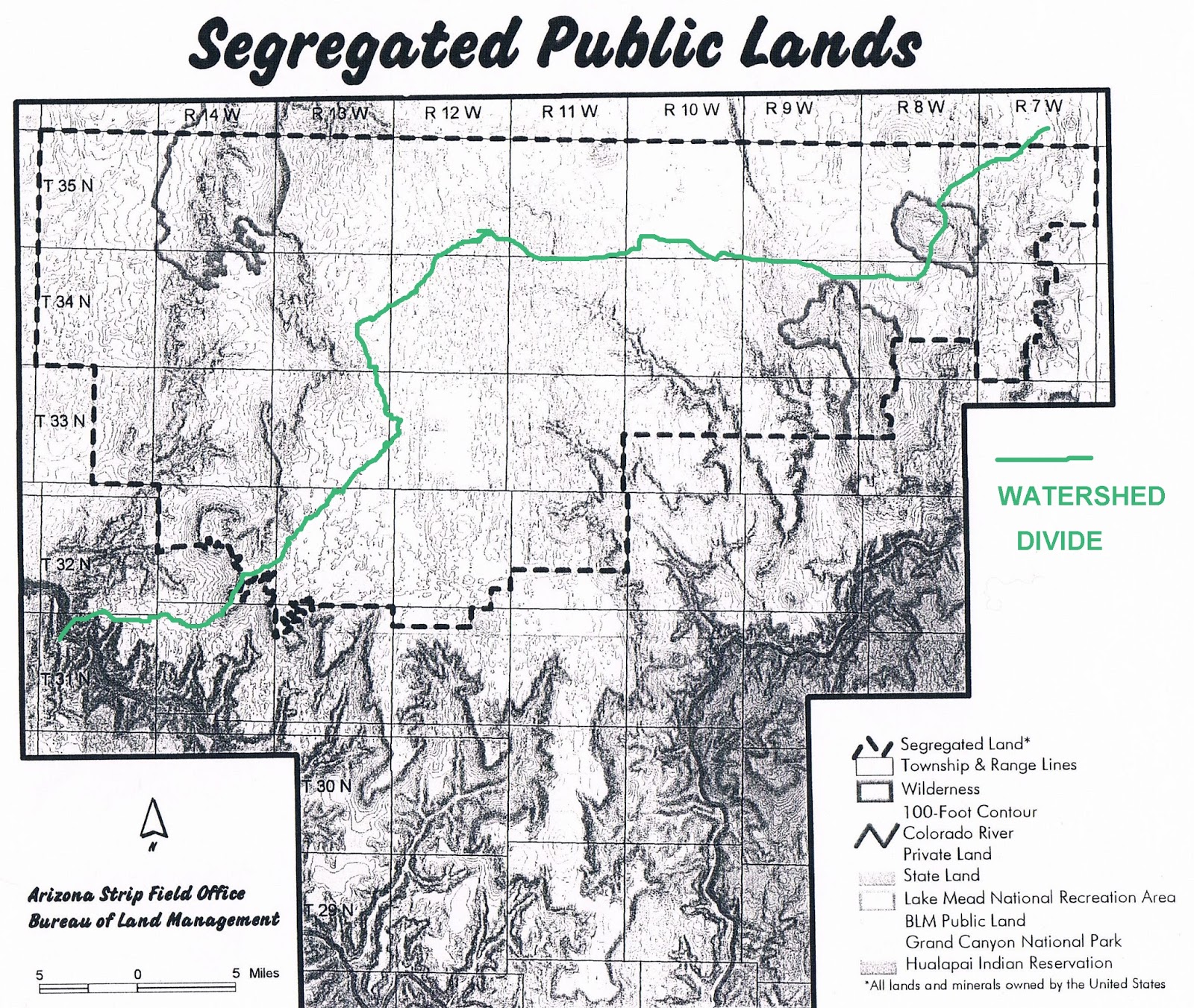
Townships in 14W & 15W as well as in 13W and 35N are part of the Grand Wash Cliffs or draining away from the Canyon, so they are not part of the watershed of the Shivwits Plateau and Andrus, Parashant, & Whitmore Canyons that drain south into the Canyon. Perhaps Babbitt thought of these townships as part of the Canyon’s watershed. But in fact, the drainage divide is actually above the Grand Wash Cliffs, running through the 13W townships and then east, as shown (roughly) by the green line.
In his recounting of this story, Babbitt speaks of taking magic markers and putting a line on a map to help his staff understand his concept. In his subsequent statements, including in his 2012 interview with me, he spoke only of the Canyon watershed. Perhaps his annotated map, if it still exists, would clarify if he intended to include lands beyond the Grand Canyon watershed.
Here is the text accompanying the segregation map, a statement as 1999 opened:

The segregation was just a preparatory step leading to the next, more important step on the new course Babbitt was setting: to make the Monument idea a very public one while it was still in the discussion stage. The statement is interesting as well for its mention of Senator McCain, who had taken a Canyon-friendly interest in previous issues. In the event, only Canyon-unfriendly legislative initiatives made an appearance. However, the Secretary had drawn up the curtain on what he hoped would be an inclusive, and constructive, public process. He was looking for a new way of ameliorating, if not reconciling, the diverse demands on the most remarkable region of our most remarkable American West.
Sources: From my files: newspaper articles, notes on my contacts, official papers, my correspondence.
2012 interview with former Secretary Babbitt
No comments:
Post a Comment